Background
In order to execute the operational tests, S-102 datasets had to be generated. In this project, the S-102 datasets were produced for specific areas that were requested along the Norwegian coastline.
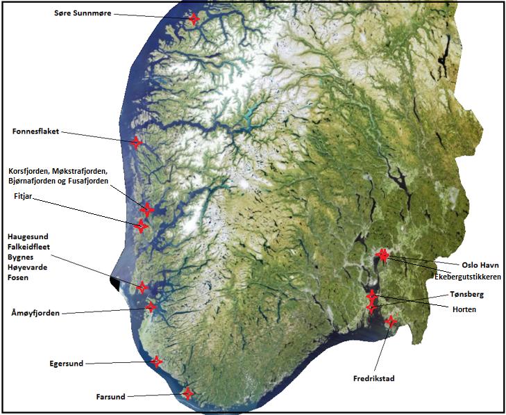
(illustration: Kartverket – Norwegian Hydrographic Service)
The project objectives – Data production
- Investigate the possibilities related to S-102 modelling in the editor application used by the Norwegian Hydrographic Service.
- Validate different modelling algorithms and when to use them.
- Validate data coverage for selected areas and the possibility of producing high resolution datasets.
Classification for Norwegian high resolution depth data
There are currently limits in place on general access to high resolution depth data for coastal sea areas. From the territorial limit and into the Norwegian coast, depth data with a point density of less than 50 metres between the points, is defined as classified information under the Security Act. The Norwegian Mapping Authority is therefore not allowed to disclose more detailed data without the prior approval of the Norwegian Armed Forces. Such data is classified CONFIDENTIAL or higher. The security classification is conferred by the Security Act and applies to all activities within the scope of the Security Act.
The normal procedure for the release of data, is for the Hydrographic Service of the Norwegian Mapping Authority to apply to the Norwegian Armed Forces at the Norwegian Joint Headquarters on behalf of the private legal entity that requires the data. The Norwegian Armed Forces have set guidelines for enquiries about the declassification and disclosure of depth data (which follows the rules on declassification in the Security Act and associated regulations). As a general rule the Norwegian Armed Forces will consent to the release of data, if it is to be used for a societally important purpose or, if it is deemed important or essential for business development. This is especially true if the data is limited to a smaller sea area. The Norwegian Armed Forces may set conditions in connection with the consent.
On October 1, 2017, the “Information Act on Specific Areas, Protective Objects and Ground Conditions” (LOV-2017-06-21-88) was introduced. The Mapping Authority is still awaiting regulations that will provide information on how to deal with the new act. A potential new and important change may be that the Mapping Authority will be awarded greater responsibility for the administration of the “grading regime”. Other changes could be that depth data from 0-30 meters will, in general, be downgraded. We do not know for certain what will be applied before the relevant regulations have been adopted.
Data Sources
Sea survey data are depth data collected through depth mapping of Norway’s coastal and marine areas. There is a distinction between older data and modern data:
- Older data is depth data collected by using older equipment such as single-beam sonar, hand-held or machine solder.
- Modern data is depth data collected by using multi-beam sonar. Older data is continuously replaced as new data is retrieved.
As of February 2019, the Norwegian Hydrographic Service database has approximately 2800 unique, quality-approved, multi-line data sets stored. However, not all of these datasets are suitable for S-102 production.
The two illustrations below show an area in the Trondheim Fjord in Norway, were there are modern data surveys available, but are not necessarily suitable to produce 1-2 meters resolutions for S-102 datasets.
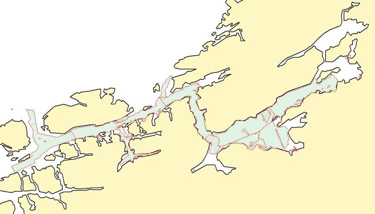
Illustrates modern quality approved multi-beam data in the Trondheim Fjord. This data will have a potential resolution of between 5 and 10 meters
(illustration: Kartverket – Norwegian Hydrographic Service)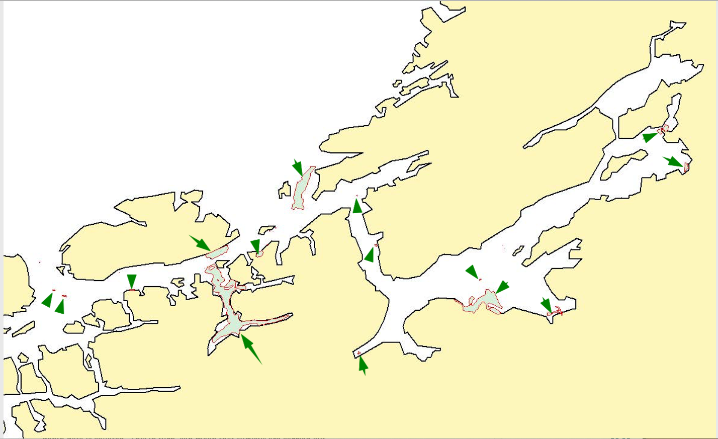
Illustrating data suitable for generating high resolution S-102 data at 1 to 2 meter resolution in the same location
(illustration: Kartverket – Norwegian Hydrographic Service)
When generating a “shallowest” surface, the uncertainty applied to the cells in the model will be too great when exceeding 2 meters of resolution.
For more detailed information relating to data modeling and uncertainty, please look at the pdf document “S-102 Modeling” which can be found at the bottom of this page.
Norwegian Hydrographic Service – Plans forward
It is still to be clarified how the Norwegian Hydrographic Service will organise the production of S-102 data. However, it will most likely implement a solution where S102 data is produced and controlled together with other navigational products.
In Norway, there is currently no official coordinated manner in which depth data is collated. This in turn, can mean that surveys are carried out in areas where mapping and depth data has already been collected, this data is then being used for only one purpose, where there could be potential for re-use.
At the same time, however, it is difficult for users to get an overview of available, reliable, high resolution depth data, detailing the limitations that apply to them and then how to access them.
There is a requirement to provide the various user groups with in-depth data through a national geographic infrastructure. In order to accomplish this, a marketplace with simple tools for downloading data will be established. This will also include the means for applying for access to graded data, or applying for permission to perform or order new surveys.
The new marketplace solution will be for high-resolution bathymetry data and derived products that will correspond to the Norwegian Mapping Authorities solution for height data (Høydedata.no).
A stipulation for the new solution will be to support a total management dissemination of graded data – allowing the Norwegian Mapping Authority accountability for the distribution and use of the various graded datasets / products, thus having full control that data is deleted / returned at the end of the life cycle, i.e. once the time-limited user permit expires.
Current planned functionality for the solution:
- Information on available depth data from the Norwegian Mapping Authority/Norwegian Hydrographic Service.
- Information on metadata for individual depth data sets.
- Overview of newly prioritised and planned survey assignments.
- Overview of which data is graded / ungraded (zones in a map solution).
- Possibility to download datasets as different products.
- Functionality for defining an Area Of Interest (AOI) and completing an application for performing a survey of the AOI.
- Functionality for defining an Area Of Interest (AOI) and completing an application to be granted access/release of a restricted/graded dataset.
- Functionality for entering coordinates and completing information about a data set that has already been mapped by others (non-graded dataset).
- Functionality for defining an area where depth data is required (and does not currently exist).
S-102 Modelling
The document below is a summary of finding and considerations while producing the test datasets. This provides a good description of the challenges related to producing S-102 datasets, especially those around which algorithms to use and when, and the elements around uncertainty.