Summary
The IHO standard S-102 Bathymetric Surface Product Specification 1.0.0 was released in 2012. At the time it was the first official standard built on the S-100 concept. In the last 3 years there has been ongoing work by the IHO S-102 project team to release an improved version of the standard.
During the project period several of the topics discussed have resulted in providing input to the IHO S-102 Project Team for standardisation. This page briefly describes and summarises the input given. Some suggestions have resulted in direct changes to the standard, and some have been postponed for the future.
During the project period the S-102 Project Team conducted 2 physical meetings:
- 16th and 18th March 2017, Genoa Italy
- 9th and 12th April, Singapore
Alongside the meetings, work has also been conducted via email communication and a Nordic workshop held in Sweden during the project period.
This page describes the following topics in more detail:
Input given resulting in direct changes:
- Coordinate Reference Systems
- New edition Coverage
- Naming convention
- Dataset Size
- Gridding Methodology
- Purpose
- Data integrity and encryption
- Data Quality
Input given but postponed for future discussion:
- Tiling Schemes
- Standard Aligned Grids
- Validation
- Single vs Multiple tile data products
- Multi resolution data products
- Grid resolution quad-tree approach
Input given resulting in direct changes
Copyrights : All tables/pictures below, and in attached pdf document, from the IHO publication “S-102_Ed2.0.0_Draft_20190315” is published with consent from the IHO (International Hydrographic Organization) and should not be reproduced without prior written permission from the International Hydrographic Organization (IHO).
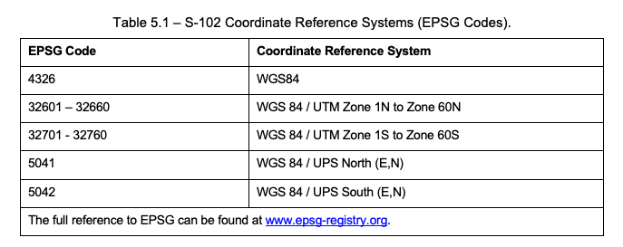
1. Coordinate Reference systems
The standard did not limit the use of coordinate reference systems sufficiently, resulting in unnecessary challenges for OEMs and Service Providers. This would have meant implementing support for too many coordinate reference systems. A limited number of systems using the ESPG code was suggested. Based on our feedback the following limitation has now been included in the new draft edition:
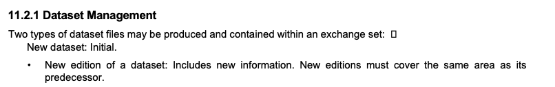
2. New edition coverage
In order to avoid confusion for end users and distributors when issuing new editions of a dataset, the newest edition should cover the same area as the previous edition. Based on our feedback this requirement has now been included in the Dataset Management section of the new draft edition:
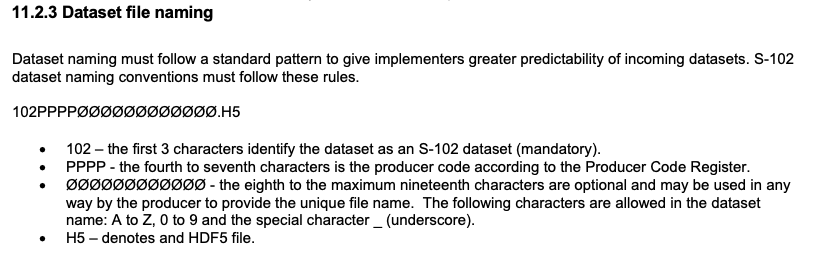
3. Naming Convention
The work conducted with S-102 has been carried out in conjunction with work on other S-100 Product Specifications, especially S-101. During this work a suggestion for a common naming convention for all S-10x products was accepted. Based on our feedback this requirement has now been included in the Dataset file naming section of the new draft edition:
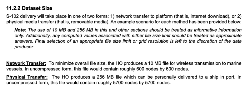
4. Dataset Size
During the project period the average size of the test datasets created ranged between 150 – 200 MB. During lengthy discussions we proposed a standard acceptance of dataset sizes to a minimum of 200 MB. It was finally agreed that the acceptance would be dependent on digital or physical transfer media. A note was added, however, stating that the sizes are “informative information only”, meaning the final selection of an appropriate file size can be decided by the data producer. Based on our feedback the following information has now been included in the Dataset size section of the new draft edition:
5. Gridding Methodology
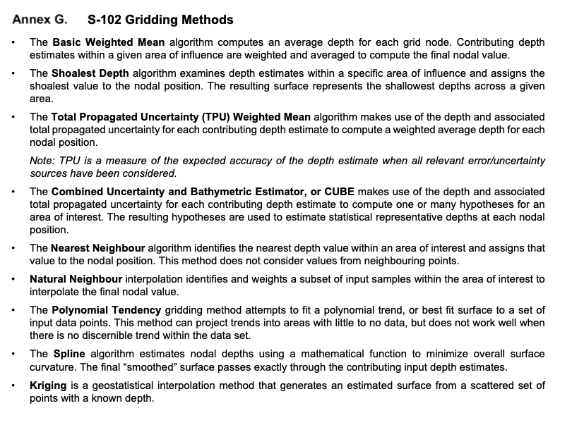
A bathymetric grid can be calculated in various ways by using different calculation algorithms. It is important to convey this information for the end user so they know which methodology was chosen for the grid calculation. Based on our feedback, the following metadata has been included in the dataset discovery metadata in the new draft edition:

A more descriptive section of various gridding methods have also been added – some of them using uncertainty in different ways. Based on our feedback Annex G has been added to the new draft edition:
6. Purpose
The standard support products being produced for 2 different purposes, navigation and “other”. It was important that details of the purpose could be encoded to inform the user whether the product was intended for safe navigation or not. Based on our feedback, the following metadata has been included in the dataset discovery metadata section in the new draft edition:

7. Data Integrity and encryption
Having sufficient data integrity and encryption is an absolute necessity for trusting the data and the data delivery. An entirely new chapter has been written in S-100 on this topic, Part 15 – Encryption and Data Protection. As part of this work, data integrity and encryption has also been incorporated in the product specification. This also includes the incorporation of the necessary metadata fields for information. Based on our feedback, the following information has been included in the Data Integrity and Encryption section of the new draft edition:
8. Data Quality
Quality discussions have been part of every project meeting. Being able to see which have quality products is important for the end user. In our initiative the IHO Data Quality Working Group (DQWG) were approached to consider how quality should be maintained within the S-102 standard. As a result of DQWGs recommendations a data quality section has been included in the standard. The new section describes the following data quality components:
- Completeness
- Logical Consistency
- Positional Accuracy
- Temporal Accuracy
- Thematic accuracy
As for sufficient methodology to portray data quality, this is still ongoing work and not part of the proposed new draft edition. There are still unresolved issues related to the display of uncertainty, and this is also relevant to other S-10x products where uncertainty is a factor. The DQWG is tasked to find a solution for quality portrayal, the result of their work may affect how uncertainty will be portrayed for S-102 products.
The issue of data quality is also strongly related to the gridding methodology as mentioned in the annex above.
Input given postponed to future discussions
1. Tiling Schemes
It was decided that further discussions related to a national tiling scheme recommendation would be postponed for a future edition of the standard.
2. Standard aligned grids
We have highlighted the benefits of producing standard aligned grids within a defined geographical area. Our intention was to implement recommendations in the standard for data product creation, outside of national predefined tiling schemes. The most important benefit being the avoidance of additional hardware calculations displaying non-aligned data together. The following figure explains visually the difference between aligned and non-aligned datasets in a UTM zone.
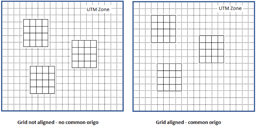
Such recommendations and discussions relating to how this should be described have been postponed for a future edition of the standard.
3. Validation
Discussions relating to data validation have highlighted that this area of the standard will be postponed for a future edition. The issue of validation is closely connected to planned work creating a common validation test section applicable to all S-100 products. The idea being all products will consist of two validation sections, one covering generic S-100 tests and the other being product specific.
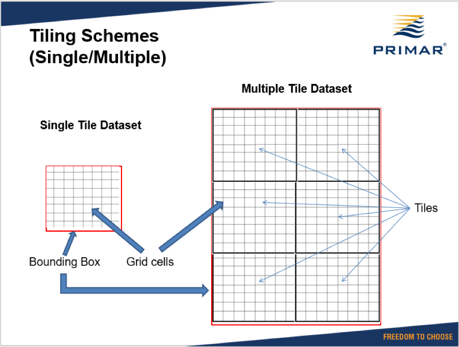
4. Single vs multiple tile data products
Discussions related to single vs multiple tile datasets have been postponed for a future edition of the standard. The idea will be to have several tiles composing one dataset:
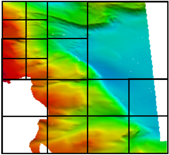
5. Multi resolution data products
Discussions relating to multi resolution data products have been postponed for a future edition of the standard. The concept of multi resolution data products would be to allow areas within a dataset to be built of different size grid cells (see image below):
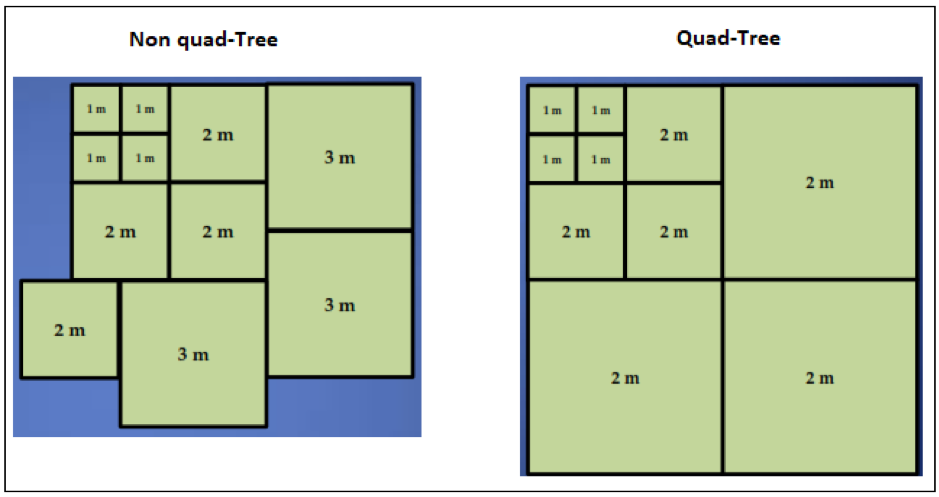
6. Grid resolution quad-tree approach
To improve the use of S-102 data when ingesting them in a terrain model, a quad-tree approach for resolution was suggested. Such an approach would affect efficient hardware processing time when moving around in a model. An example of quad-tree vs no quad -tree:
A recommendation has been included in the standard where informative grid resolutions related to various display scales are listed:
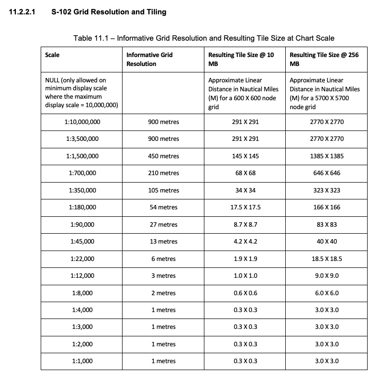
This is currently not reflecting a quad-tree approach, and the producer will have to choose resolutions outside of the recommendations to produce accordingly. Further discussions will hopefully result in extended recommendations for the quad-tree approach.