Status Winter 2018 – Hydrographic Offices and System manufacturers
Why
We wanted to understand the the S-102 status, needs, expectations, technical challenges, wishes and adaptations beyond the project partners in Norway.
To obtain this knowledge we chose to invite relevant stakeholders to conduct a web-based questionnaire in which they could provide their feedback.
The objectives were:
- Learn how system manufacturers wanted to support their users with new functionality using bathymetry data.
- What factors determine when they want to support new products in their systems.
- Identify and gain further knowledge around the approach the Hydrographic Offices plan to take – are there ongoing initiatives for production and delivery of the S-102 product?
- Highlight concerns and any challenges the Hydrographic Offices foresee, and use this information as input to the S-102 standardisation work (input to the new S-102 standard).
When
The questionnaire was conducted during the winter/spring 2018. Please be aware that views could have changed during this last year.
Seven Hydrographic Offices and five system manufacturers completed the questionnaires.
The following questions were put forward to the Hydrographic Offices – producers of S-102 data

Question 1: Could you describe your planned production, related to a timeframe and any national restrictions?
Conclusion based on feedback:
- 3 of the 7 Producer planned to have more data available within one year (within 2019)
- A ratified version 2 of the standard is crucial for starting production
- National restrictions are present for some of the Countries – this limits access to data in some areas.
Question 2: What should the size limit be for an S-102 file? Any other considerations regarding file size?
Conclusion based on feedback:
- The size limit should be > 250 / 300MB
- A common agreement is needed on the file size.
- Challenges and limitations related to file size in end-user systems needs to be addressed.
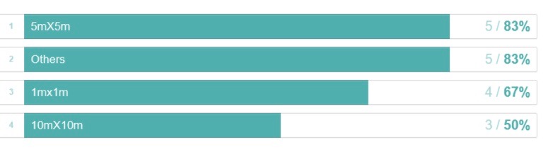
Question 3: Which resolutions will you produce (1mx1m/5mX5m/10mX10m/Others)?
Conclusion based on feedback:
- The majority will produce several grid sizes.
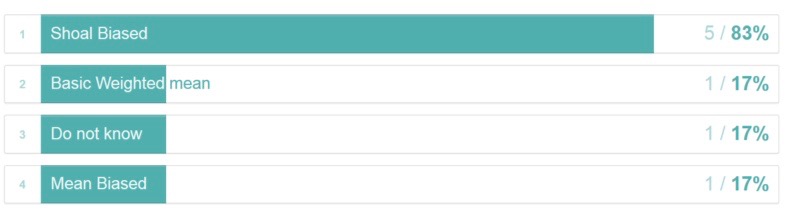
Question 4: Which algorithm will be used to create datasets from source material (Mean Biased/Shoal Biased/Others/Basic Weighted mean)?
Conclusion based on feedback:
- Shoal bias was most frequently mentioned.
- The importance of being able to describe the type of algorithm used In the metadata is emphasised by several of the producers
- Ability to differentiate between algorithm for grid method / sounding selection
Question 5: S-57/S-101 versus S-102 – any views on conflicts in end user system (S-102 shoaler than ENC, ENC shoaler than S-102)? Which coordinate system will be used in S-102?
Conclusion based on feedback:
- It is assumed that the conflict will be greatest when S-102 provides less navigable waters than the ENC.
- The plan is for at least one producer to base the ENC production on S-102 data, to avoid mismatch
- Different coordinate systems will be used: EPSG: 3301 or WGS84 (EPSG: 4326), UTM, WGS84UTMN, UTM34, Mercator projection (EPSG:: 3395), UTM (EPSG: 25832).
Question 6: Could you define PRIMARs role in your future S-102 validation and distribution?
Conclusion based on feedback:
- PRIMAR should do the validation and distribution – as they do today for S-57.
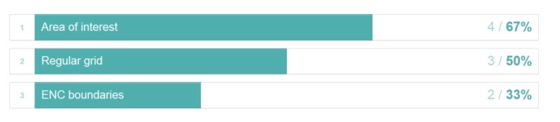
Question 7: What will you produce data based on, e.g. area of interest/ENC boundaries/regular grid?
Conclusion based on feedback:
- No clear preferred method.
- Regular grid could possibly be adapted to recommended tiling schemes in the standard.
Question 8: Do you have any idea if/when/how you would encode uncertainty and how this should be viewed for the end-user?
Conclusion based on feedback:
- Quality parameters: Uncertainty, CATZOC, S-44 Orders.
- Other possibilities: Colour coding, simplified classification.
- Important how uncertainty is presented and understood – determine what is useful information for the end user.
- Important to be aware that different stages of the production process can affect quality: Collection of data / Processing and gridding / display of data.
- It is important to agree on a common practise of how uncertainty should potentially be coded and displayed. Work is ongoing to get this into the standard:
- Data Quality Checklist (ISO based)
- For position accuracy use – RMSE (Root-Mean-Square-Error)
- Metadata on basis for uncertainty calculation.
- Metadata on grid algorithms.
- Metadata describing whether the terrain’s slope has been calculated into the uncertainty
Question 9: Do you have any views regarding updating of datasets?
Conclusion based on feedback:
- The seabed’s topography, bottom condition, weather, current, tides etc. are all factors that together effect the seabed differently, over different times and in different places.
- Economics, priorities, social responsibility etc also affect when and which areas need new surveys.
- Based on the feedback provided, it is not possible to identify one solution as to when datasets will be updated as it varies depending on the different factors listed above.


The following questions were put forward to System Manufactures (OEMs) of ECDIS , ECS and PPU systems
Question 1: Does your system currently support the S-102 standard? If not, do you plan to support the standard in the future and when?
Conclusion based on feedback:
- None of the OEMs currently (2018) have support for S-102, however, they either have ongoing Proof-Of-Concept projects or have plans to start working on a beta/prototype shortly.
Question 2: Any views regarding data product coordinate systems that are used in the standard?
Conclusion based on feedback:
- 3 out of 5 want geographic systems such as WGS84 (EPSG: 4326) to be used, instead of projected systems
Question 3: How do you plan to install the data into your system, are there any limitations due to the size of dataset?
Conclusion based on feedback:
- Very varied reactions to this question with no “one size fits all” :
- Some felt that file size could be an issue
- Limitations to broadband connectivity at sea were highlighted, but one assumes that most downloads will be done near shore/in ports hence connectivity is maybe not such of an issue.
Question 4: Are many of your customers requesting bathymetric data?
Conclusion based on feedback:
- Yes, interest and requests for S-102 data is increasing
Question 5: What kind of users/customers are asking for the data and for what purpose (navigation, planning, anchorage, etc)?
Conclusion based on feedback:
- Requests are mostly coming from Pilots who would like the data for navigation and planning purposes.
- Safe navigation in confined waters and waters with strong tidal influences
- Planning dredging activities
Question 6: S-57/S-101 versus S-102. Any views upon conflicts in end user system (S-102 shoaler than ENC, ENC shoaler than S-102)?
Conclusion based on feedback:
- When S-102 data available S-57 depth information could be for reference only
- Most reliable / up-to-date information should have priority
Question 7: Do you have any ideas as to how uncertainty information could/should be displayed for the end user?
Conclusion based on feedback:
- Some of the OEMs would like to decide themselves how this is to be presented
- Have it as an optional layer (switch on/off)
