The 4th operational test with the S-102 Demonstrator was carried out by NCA marine pilot, Modstein Hansen, at the offshore “Kårstø gas terminal” on the southwest coast of Norway.
The first part of the test was carried out aboard the LPG Tanker “”Kithnos”. During the test, the Pilot Plug was used to project the tanker position into the S-102 Demonstrator application. The S-102 provides an impressive picture of the bottom topography where one can clearly distinguish between hard and soft-bottom sediments, which is extremely important information when planning secure anchor positions. On a traditional ENC there are limited opportunities to extract this type of information. The Captain of LPG “Kithnos” was very impressed with the possibilities of the S-102 standard and data. He could clearly see the value of having access to use S-102 bathymetric data in terms of safe navigation and anchorage.


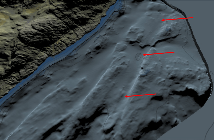
The second part of the test was completed aboard the oil tanker ”M/T Ardmore Enterprise”. The vessel was to be piloted from the anchorage area on the “Hervikfjorden” heading to “Kårstø” gas terminal. The vessel had been lying on anchorage in soft-bottom sediments northwest of a shallow. “Hervikfjorden anchorage area” is used by large ship tankers to enter the “Kårstø gas terminal”. The ENC image below shows the anchor positions currently used in this area. As one can see, the common ENC “approach band” gives very little information about terrain formation and ground conditions that are important for anchorage.

Compared to the image below from the S-102 Demonstrator, of data in the same area, it is obvious that this provides a completely different and far more detailed picture of both topography and bottom conditions. Notably, the best anchoring positions are not on the shallow peaks that we easily see consists of mountains, but in deeper valleys where the bottom is covered with what we can interpret are soft-bottom sediments (see red arrows on map views). This also correlates with the knowledge and experience the marine pilots had based on the fact that the anchoring positions in this area was previously selected using specially ordered maps to determine the bottom state.